Rain smeared the windows as Bus #20 lurched hastily down East Hastings towards the city center. My eyes scanned the street-- the 4-Leaf Clover Pawn Shop, a broken window, a man yelling to himself, Budget Inn, barred up storefronts, a Chinese shop, people waiting for the bus, the First United Church Housing Society. The scene panned out in front of me like a movie reel. I got off at Gore Street with a grizzled man with a long beard and walked down Hastings. The stale smell of cigarettes and piss lingered in the air as I passed gaunt bodies pushing their lives around in shopping carts. Its not hard to see why the Downtown Eastside (DTES) is considered “Canada's Poorest Postal Code”. Vancouver's central business district and upscale neighborhoods are located just blocks away. So why is there so much homelessness and poverty centered in this particular neighborhood? What is the future of the DTES?
_____________________________________________________________
 Where is the Downtown Eastside and what problems does it have?
The Downtown Eastside (DTES), is comprised of Chinatown, Gastown, Oppenheimer Park, Strathcona, Thorton Park, Victory Square and an industrial sector. Notorious for the high frequency of HIV, prostitution, drug use, crime, and mental illness, the DTES has been struggling with poverty and homelessness since the early 1980s. In 2001, the median house-hold income was $12, 084, less than a third of the median income for Vancouver. Close to 40% of the population's income is from government welfare, and 22% are considered unemployed. Many people live in Single Room Occupancy Hotels, non-market Housing, or Special Needs Residential Facilities. Despite having the highest number of low-income housing options in Vancouver, there is still quite a large homeless population in the DTES. In 2008, the homeless count was totaled at 1,576 people in Vancouver, many of which reside in the streets of this area.
How did the DTES become “Canada's Poorest Postal Code”?
History
 The DTES was Vancouver's city center at the turn of the 20th century. Gastown's sawmills generated an industrial section and the Burrard Inlet Port brought in thousands of tourists and passengers on the steam ferries. Many Japanese immigrants were drawn to the mill and formed a “Little Tokyo” community, where they lived until they were placed in internment camps or relocated when WWII broke out. Remnants of the Japanese influence can still be seen in this area, including an old sign for the department store T. Maikawa Shote and a Japanese Community Volunteers Association on Powell Street. The city hall, Carnegie Library, a public market, and many theaters made it the cultural and commercial hub of the city. To accommodate the tourists and travelers who entered the city through the port, many hotels were built. In 1906, however, a new courthouse was built on Georgia Street, creating a push towards the west. The library was moved westward as well. Streetcar operations in the area were shut down, and the ferries stopped running a year later. With less pedestrians and a shift of the city center westward, offices began moving and businesses began shutting down. Rent dropped, and the area became attractive to lower-income families and single men, who began living in cheap rooms in hotels and frequented many of the cheap beer parlors. In 1970, a large population of mentally-ill patients were drawn to the cheap rent and community in the DTES after funding cuts and a de-institutionalization in local hospitals. The situation worsened in the late 1980s when drug users switched from heroine to cocaine. As more and more people became addicted, theft and crime became more prevalent in order to support their addictions. Many women resorted to prostitution. In 1993, the famous Woodwards department store finally shut down. The progression of events in history eventually led to the current situation of poverty and homelessness.
How can lower-income sections of the city be explained through urban geography?
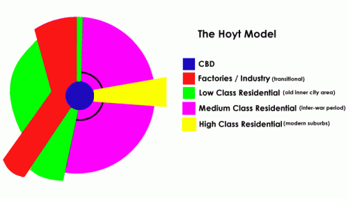
 In 1939, economist Hector Hoyt developed the “sector model” to explain city development. He argued that cities develop in wedges centered around the Central Business District along major transportation routes. The more access to each wedge there is, the more affluent they are. Low-income sections of town are likely to border industrial zones or railroads. This model explains why the Downtown Eastside deteriorated when transportation to the area was cut off. There was less access to the city and bordered an industrial section of the town; therefore, it was a less-desirable location for upper and middle class families to live and rent decreased.
What is being done or can be done about poverty and homeless ness in the DTES?
Social activism of community members as well as government funded organizations offer a variety of services. Soup kitchens, shelters, advocacy organizations, women's support groups, and even the country's first safe drug injection sight (Insite), can be found on every street in the core of the downtown Eastside. Community centers and churches such as the Lifeskills Centre, Ray-Cam Center, First United Church, and the Union Gospel Mission, offer assistance with health related issues, applying and dealing with welfare, provide food and clothing, and offer counseling for drug-related issues. The Downtown Eastside Resident's Association (DERA), have significantly improved living conditions for many DTESers by demanding safe living conditions from the government and landlords. Additionally, they advocate against gentrification of the area, arguing that rent prices will rise with an increase in gentrification, displacing many of the current residents who would no longer be able to afford housing in the area.
What changes are taking place in the DTES?
 Walking around Cordova, Carrol, and Hastings, many empty lots and boarded up buildings have 'for sale' signs hanging on them. The new Woodwards complex opened in September 2009, and is a combination of market housing and social unit housing. Although some development is occurring, I don't believe that the area will become gentrified to the point of dislocating its current residents. The DTESers have a strong social community and are actively combating development plans. My hope is that more social housing projects are introduced and the education and incentives currently in place for youth contribute to less drug use in future generations. _____________________________________________________________
After walking around the DTES for a few hours, I got back on the bus and headed back to my home on Commercial Drive, watching the landscape's movie reel in reverse through the foggy window. I got off at Hastings and Commercial and walked down the Drive. The Italian flag above Cafe Roma caught my eye, a hint to the neighborhood's history as home to many Italian immigrants in after WWII. Visiting the DTES and doing some research on the area made me more aware of how a city's history and location of specific neighborhoods can so strongly affect its current culture and community. Perhaps conditions will improve in the DTES with new housing projects, or perhaps the community will eventually be displaced by increasing gentrification. Just a 15 minute bus ride away from "Canada's Poorest Postal Code", where hundreds of homeless were making up their beds under overhangs on cardboard, I crawled into my own bed. So close to the DTES, yet worlds apart.


